Photogrammetric drone mapping for quarries, contractors, and site engineers. Point clouds, orthomosaic maps, and stockpile volumes — accurate to ±2% for billing reconciliation, quarterly reporting, and earthwork verification.
Each flight is captured with controlled overlap and ground control points where required, then processed in industry-standard photogrammetry software.
Dense LAS/LAZ point clouds delivered for use in CAD, GIS, and engineering workflows. Compatible with Autodesk Recap, Civil 3D, and Bentley.
Geo-referenced high-resolution aerial maps with 1-3 cm ground sample distance, exported as GeoTIFF or PDF.
Cubic-yard calculations for aggregate, mulch, fill, and reclamation piles. ±2% accuracy with check measurements documented.
Contour lines, slope analysis, and elevation rasters for site planning, drainage studies, and grading verification.
Quarterly comparison reports showing material added or removed between flights — ideal for monthly reconciliation.
Branded PDF reports with executive summary, methodology, accuracy statement, and dated signature for engineering record.
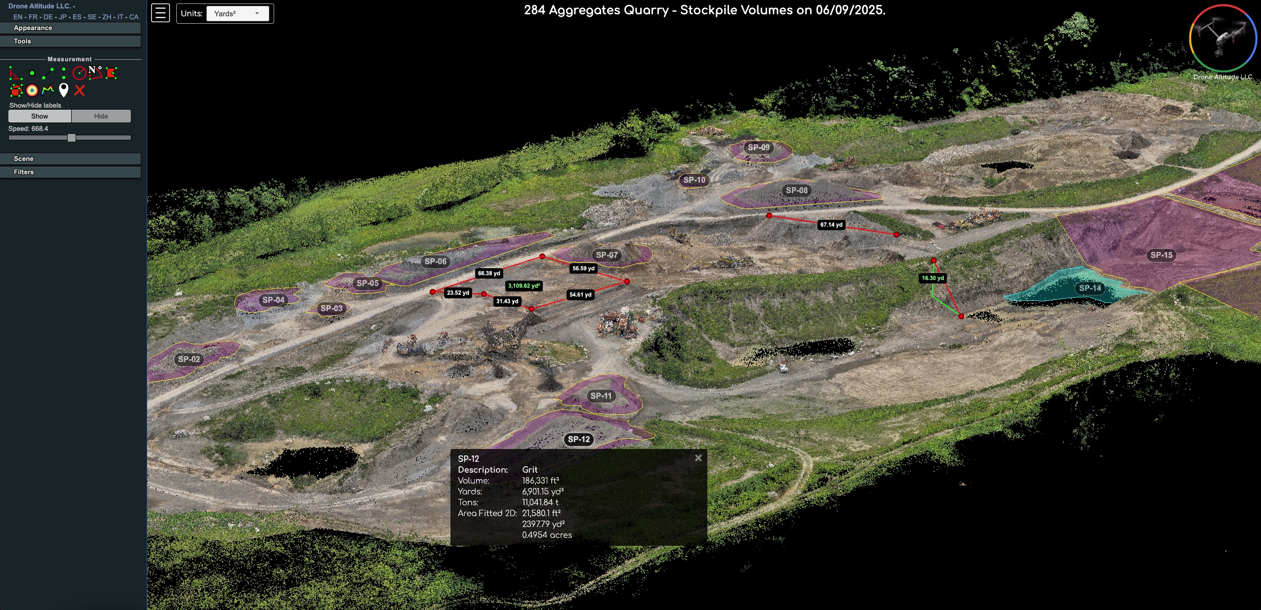
284 Aggregates Quarry — Stockpile Volumes, 06/09/2025
Stockpile reconciliation against truck tickets is a ledger-level exercise — and aerial photogrammetry, done right, produces volume figures that hold up in audits, inventory reports, and tonnage reconciliations. Using DJI drones paired with the D-RTK 3 Multifunction Station for centimeter-level GPS positioning, we capture survey-grade data and process it into 3D photogrammetric models accurate to ±2% on standard stockpiles, with documented methodology on every delivery.
Each project becomes a custom-built, browser-accessible 3D model — not a generic template. Clients explore their data directly: cubic-yard volumes for aggregate, mulch, fill, and reclamation piles, elevation profiles, and stakeholder-ready site presentations — all from a single project link.
For buildings, parking lots, and developed sites, photogrammetry unlocks geometry you can’t easily measure from the ground. Captured with DJI drones running the D-RTK 3 Multifunction Station for survey-grade positioning and high-resolution imaging, every project becomes a 3D model supporting precise distance, area, height, and angle measurements across residential, commercial, and multi-unit properties. Common applications include roof inspections, walkway and pavement analysis, parking layouts, building footprints, sports court measurements, and clearance studies between structures.
Each project is delivered as a custom-built, browser-accessible 3D model — not a generic template. Useful for portfolio management, maintenance planning, construction estimates, insurance documentation, civil engineering, due diligence, and dispute resolution — all with the same ±2% accuracy and engineering-grade methodology, shareable through a single link.
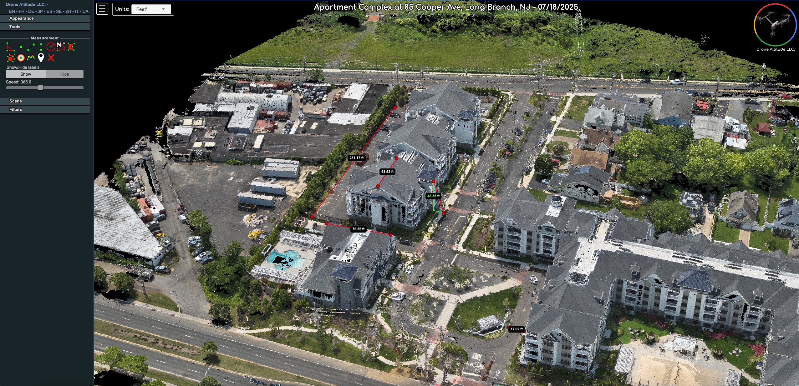
Apartment Complex at 85 Cooper Ave, Long Branch, NJ — 07/18/2025
Each pointcloud opens in an interactive viewer. Here’s how to move around and take measurements once it’s open.
Left-click + hold, then drag to rotate the model in 3D.
Right-click + hold, then drag to slide the model across the viewport.
Scroll with your mouse wheel to zoom in or out at any time.
Hover over any label in the viewer to see additional information about that feature.
Open the Measurement tab in the sidebar, hover to identify tools, click to select. Left-click to start and continue a measurement, right-click to finish or close a polygon.
Either remote (you send a parcel map) or on-site for larger projects. We confirm scope, accuracy targets, and access.
Automated mission with controlled overlap (typically 75% front, 70% side) at altitude tuned for your accuracy spec.
Cloud photogrammetry pipeline produces the orthomosaic, point cloud, and surface model. QC pass before delivery.
Branded PDF report plus raw GeoTIFF/LAS files delivered via secure download link. Q&A call included.
Send us your site address and stockpile count and we'll respond with a quote and flight schedule.
Request a Quote