FAA Part 107 certified drone services for commercial real estate, construction monitoring, 3D mapping, and thermal inspections.
Every flight is captured by an FAA Part 107 certified pilot, processed in-house, and delivered as broker-grade or engineering-grade output.
Cinematic property tours with graphical overlays, parcel boundaries, and walk-through narratives — built for brokers who need their listings to stand out.
Learn more →Photogrammetric point clouds, orthomosaic maps, and stockpile volume calculations accurate to ±2% — for quarries, contractors, and site engineers.
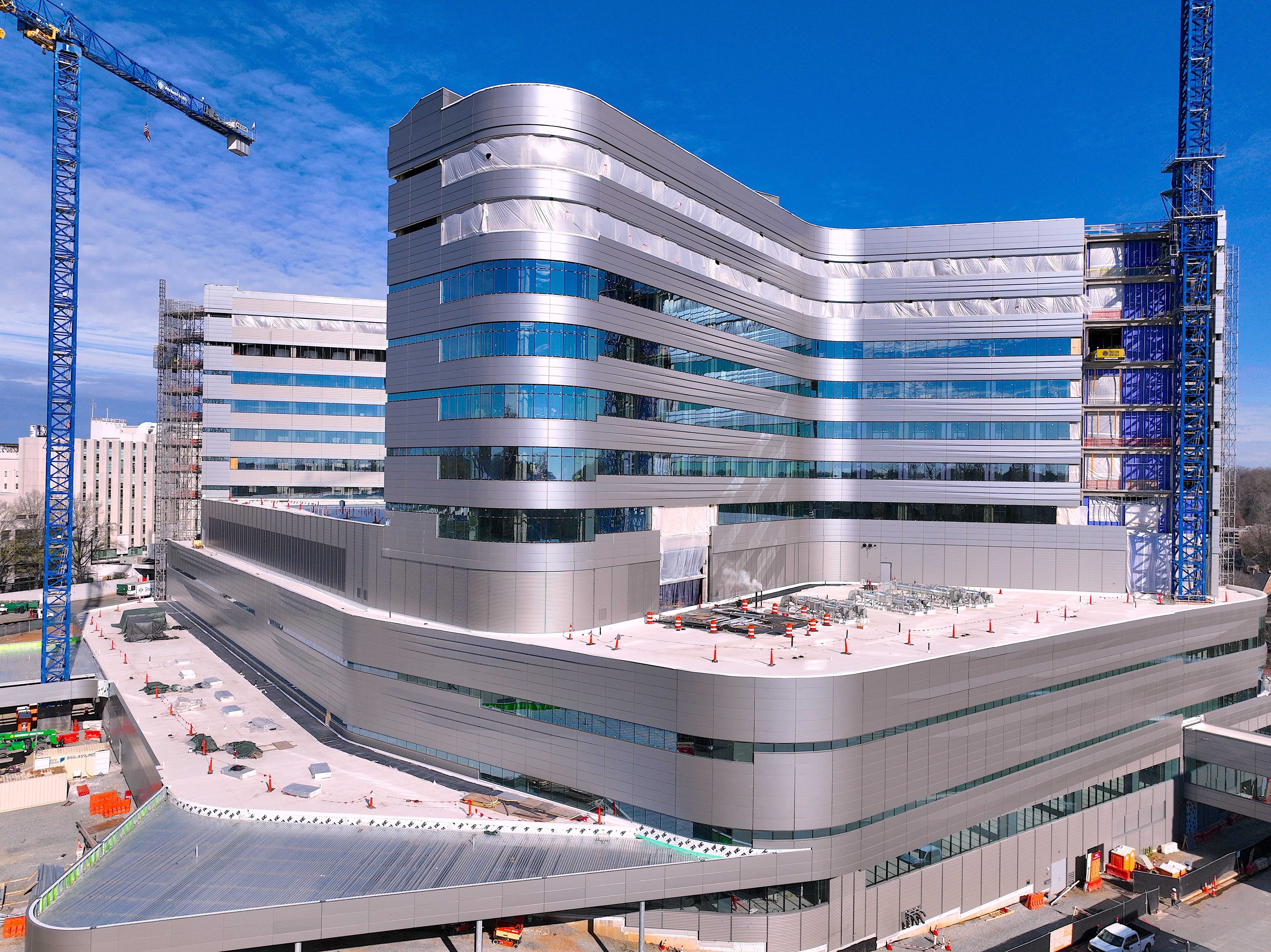
Learn more →Monthly progress documentation, full-build time-lapse sequences, and lender-ready reports — a single trusted source from groundbreak to topping out.
Learn more →Radiometric thermal imaging for roof moisture surveys, solar panel diagnostics, and building envelope inspections — flagged anomalies in a written report.
Learn more →Interactive aerial 360° panoramas that let buyers explore a site from every angle — or multiple properties linked into one immersive portfolio tour.
Learn more →Drone Altitude is a Lake Hopatcong, NJ–based commercial drone services company serving the NJ Tri-State and surrounding states. We focus exclusively on commercial work — real estate, construction, mapping, and inspection — with the credentials, insurance, and processing workflow each segment requires.
Every flight is conducted by a Part 107 certified pilot. Every deliverable is processed in-house. Every project is treated as an asset our clients will share with their stakeholders, lenders, or buyers.
Learn About UsA look inside how we approach institutional and commercial documentation — from facade work for architectural panel fabricators to long-term construction and quarry monitoring engagements.

Hi Paul,
After review, the photos you provided were outstanding! You captured exactly what we were looking for, the updated facades, and shots from multiple angles. My SVP was impressed with the shots of the entire plaza from across the street and then from the side view. Thank you for the video, that was a nice touch. We appreciate your quick response and delivery and I will be sure to reach out if we need further shots in the future.
Thanks for the work you did for us! A++
Paul—
For the record Paul Komosinski is a pleasure to work with and a true professional. Unlike others, he loves the art of making stunning photography and drone videos. Ever the post-production professional, he takes notes, makes changes, and expertly delivers on the client’s highest expectations. I will use him for all my drone work going forward. I highly recommend him to anyone who wants seamless, superior quality work.
Paul gets it done the first time — and gets it done right!

Hello Paul –
Wow! My team and I are thrilled with your work! The video and the photos you took were amazing. It’s a great marketing tool for us. The feedback from our clients and partners has been excellent. We expect a boost in revenue due to the marketing gains we will receive from the video. Thanks for being so easy to work with and helping us come up with a vision for the video. Please do not hesitate to call on us if you need a reference. We look forward to working with you again when we complete the next phase of our project.
Thanks again,
Paul –
Thanks, Paul. Looks really beautiful. I’ve forwarded along to my Sales Manager, Blair, and will get back to you shortly… Blair thought this was amazing! Very happy with the video. No edits on our end. Approved. I know we’ve asked you to do Hawk Pointe also — we are going to add the following two communities so as to do a bundle of 4.
Thank you,
Paul,
We were really impressed with the drone video you provided us. The space we asked you to video was very tight with both construction material and lab equipment and it had low ceilings! We were all really impressed with how you were able to maneuver in such limited space yet still were able to capture all that we wanted to see in the video. Your response time was excellent and we appreciate you flexibility. The video editing was also excellent. I know we made some changes on you with what we wanted to show but Drone Altitude made the video everything we were looking for. We are exciting to continue our partnership with Drone Altitude!
Thanks,
Paul –
It was a pleasure working with you on this fantastic project. I am blown away by the technology that a simple drone can bring to a industry. The video is a great aerial view of the site and you should be commended for your ability to put it together. I think the video is fine the way it is if I decide to use it as a constant running video on a smartboard or TV here in the office. Photos in the video would be too much repetitiveness.
Thanks –
Paul,
I would like to thank you for making me look good. Out of the companies I contacted you are the only one who answered questions I did not know to ask. You did not hesitate when I let you in on the finer details of the project and my Project Manager mentioned your professionalism on site and ability to “stay out of the way” which is of the utmost importance for the job you were hired to do. My only hesitation in giving you a glowing recommendation is my fear of not fitting into your schedule the next time we need your services. Thank you for your exemplary competence, I look forward to working with you again.
Sincerely,
Tell us about your property, project, or site. We typically respond same-day with availability and pricing.
Request a Quote